PROTARAS, A WORLD-FAMOUS TOURIST CENTER
A narrow coastal plain stretching about 5km northwest of Gkreko to the east of Paralimni, has been given the name “Protaras”, a name well-known among international tourist circles. The true Protaras is, quite possibly, the site of ancient Lefkolla, that which, today, is the small cove with the fine-grained sand and the little island, which the British christened “Fig Tree Bay”. Wave-kissed coasts with jagged promontories and sandy bays, little isles and isolated rocks, sea caves and arches formed by the waves, a few scattered irrigated plots of fruit trees and vegetables, thousands of windmills, most of which still give a turn under the slightest gust of wind and an abundance of ponds where, at night, you can hear the croaking of the frogs, all these make up Protaras. Sprouting day by day on this natural scene are hotels, tourist apartments, souvenir shops, supermarkets, restaurants and many other tourist-related establishments. Lying on the warm beach of Protaras, gazing at the isle across the water, visitors from abroad know little about the ancient town of Lefkolla, the city-port that Strabo mentions, where Cesnola discovered artifacts of Greco-roman origins. This locality is indeed very ancient. A series of little islands adorn the coast of Protaras, known to the locals as “Nissia”. Recent excavations at Nissia revealed 28 houses and a wall. Pottery, stone instruments and horns of deer have been found. The settlement is considered to be neolithic. The isolated chapel of Profitis Ilias, built in carved reddish limestone, lies on a solidary outcrop dominating the area. The church we see today was rebuilt in 1984, on the foundations of the old church which had almost been in ruins. Small, elegant and with no extra frills, following the byzantine rhythm of architecture, with plates built into the walls, it contains a tiny iconostasis with icons drawing their subjects from the life of Christ. The view from the outcrop is truly unique.
Map of Paralimni Paralimni Map Photo Gallery


Profitis Ilias Protaras
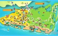
Map of Paralimni – Hotels and Attractions on a Paralimni map
PARALIMNI, THE CAPITAL OF THE FREE PART OF FAMAGUSTA
The Turkish invasion of 1974 has not just transformed Paralimni into a border community. It has, at the same time, positioned the invaders at the doorstep of the present capital of the district of Famagusta. This may be a reason that the historical town of Paralimni, despite the adversities it faces, is growing constantly and is exhibiting an unprecedented economic growth. It is quite possible, from what historians and travellers write, that in the past Paralimni was a place of exile and unimportance. Jeffery (1918) mentions a modern settlement of no particular interest while G. Voustronios (15th century) talks about a courier of Faranto who was expelled and exiled to Paralimni. According to Mas Latrie, however, it used to be a royal estate during the Lusignan and Venetian periods. You can visit Paralimni by following the picturesque coastal road connecting Agia Napa, Gkreko and Protaras. It is a route full of contrasts, beauty, colour and tourist activity. There is, however, an alternative, shorter route via Xylofagou and Agia Napa. Paralimni (translated in English , “by the lake”), obviously obtained its name from the neighbouring lake. It is a large hollow where water collects only in winter months. A part of the lake has already been converted to other uses.
Pernera
According to Mas Latrie, the lake of Paralimni was the site for a number of activities. Freshwater fish was bred in the lake and rice was grown in its environs. As currently, beccoficos and other migratory birds used to make a stop at the lake on their way to Africa and Asia. Within the municipality of Paralimni side by side with the modern buildings, one can still see a number of traditional homes, the last survivors of an era which is abandoning us forever. The growth of Paralimni is not just touristc and demographic but includes the areas of commerce, economy, education, recreation and administration. The core of the settlement still remains fairly compact in the center of the village with the outlying areas slightly more liberal. In the center of the municipality you can still see the farmers enjoying their coffee, talking among themselves and acting in ways which betray their agricultural background, reminiscent of years gone by. Of special interest, however, are three churches which the visitor cannot pass by: the contemporary church of Agios Georgios is exceptionally large and three-aisled, the middle one being the largest.
Map of Paralimni, Ammochostos – road map, satellite view and street
White daisies in the fields
The church is built according to the byzantine rhythm and has a walnut iconostasis, whereas at the same time it is completely covered with contemporary frescoes. The large fresco depicting the All-Powerful, inside the dome, is framed by the Archangels, the Prophets and the Evangelists, writing their gospels in moments of absolute and concentrated thought. The inner sanctum is decorated with scenes from the Scriptures and Saints. Next to the present-day church of Agios Georgios, is an older church, dedicated to the same saint, dating back to the last century. In contrast to the contemporary church, this one does not contain many frescoes. There is, however, a gilted iconostasis with images in bas-relief, as well as several portable icons also dating back to the last century. The extremely thick walls of the church impress the visitor and it is worth noting the Gothic rhythm in which the church was built. The church of Panagia (the Madonna) appears to have been built with two chambers, even though it is obvious that the southern one was a later addition. The church was enlarged when it could no longer house the increase in numbers of the congregation. Some residents mention an original, very old church, dedicated to Agia Anna and dating back to the 13th century. The interior of the church is in the shape of a cross and has a dome. Later, Gothic elements were added, reminding us of the Frankish occupation of the island. Built of local limestone rock, it used to be totally frescoed. Only a few traces reveal its lost grandeur. Instead of frescoes, the interior of the church is adorned with enshrined colourful plates of a more recent origin. The carved iconostasis belongs to the 17th century, as do two large portable icons, that of Christ the Saviour and that of the Mother of Christ. One can see excellent examples of the Orthodox tradition in the church, items such as gospels, ecclesiastical blogs, holy utensils, candlesticks and others.
The stadium of Paralimni with a capacity of 2300 spectators, caters for football and athletics.
Exploring the villages of Kokkinochoria
Deryneia. Built between Paralimni and Famagusta, Deryneia has become an outpost of struggle and resistance, since the many anti-occupation demonstrations either start or end at the village. One can gaze upon the occupied city of Varoshia, along with its towering beach-front buildings and other works, some of which belong to residents of Deryneia, by climbing a relatively low rise. One can admire the local architecture by seeing the traditional homes with their impressive entranceways, supported by thin columns. Of all the churches strewn within the administrative boundaries of the village, the visitor should distinguish two: that of Panagia (the Virgin) and that of Agios Georgios. The church of Panagia is old, built in Byzantine rhythm, though not belonging to that era. The narthex, the south chamber and the western section, now a women’s gallery, were probably, as an inscription mentions, added on to the church during the 18th century. The church of Agios Georgios which is probably older than the church of the Virgin, cruciform and domed, probably of Byzantine origin, contains worn out frescoes. The northern section, added at a later stage, is arched and contains no traces of frescoes. The church was originally completely covered with frescoes, even though today one can only see the fresco of Agios Georgios and a few others.
Famagusta, as it appears from Deryneia
Sotira. Sotira, a large agricultural village of Kokkinochoria region, stands west of Paralimni lake. Apart from its rich traditional architecture, it is known for its cultural heritage, particularly its medieval and contemporary churches. Two old monasteries (Agia Thekla and Chordakia) do not function anymore. The church of Metamorfosis (Transfiguration of the Saviour), three-aisled with an impressive iconostasis and capitals at the entrance, lies within the settlement. The old, domed, 16th century church of the Saviour, was initially larger. The church of Agios Mamas, cruciform and domed, an elegant little building dating back to the 15th century, still contains a few worn frescoes. Around the church one can see broken columns and capitals. The church of Agios Georgios Chordakion, outside and just west of Sotira, is also cruciform and domed. It was built in the 12th century, while a narthex, in the shape of a cross and possessing a dome, was added on to it. In this way, two domed churches joined internally, constitute an architectural building of beauty and an attractive monument. The church of Panagia Chordakiotissa, probably also dating back to the 12th century, is small, cruciform and domed with two niches in its interior left and right of the entrance.
Basket-making at Liopetri
Liopetri. Liopetri with traditional buildings side by side to modern ones, lies 14km west-north-west of Agia Napa. The village is well-known for the art of basketweaving. This traditional art, which often requires artistic and aesthetic qualities, is practised during the summer and autumn months in the yard of the house. The focus of village life is the central village square where one finds the village coffee shops and the medieval church of Panagia Eleousa (Virgin Mary). The medieval, domed church of Panagia Eleousa built in Byzantine rhythm, impresses with its gilted iconostasis, its portable icons belonging to the last century, the fresco of the Virgin of Mercy on the north wall and that of Saint Mamas on the south one. The large, domed church preserves two belfries, archways, vaulted ceiling and a relatively large churchyard. The 15th century chapel of Agios Andronikos, built in a cruciform Byzantine rhythm, today containing but a few worn paintings, was, at one time, entirely frescoed. Its interior is dominated by an octagonal dome with eight rectangular skylights. Another stop that the visitor to Liopetri almost has to make is at the “Barn of LiopetriIt was in this barn that three youths made their final stand on September 2nd, 1958 and etched a glorious page of heroism in the history of Cyprus. At this spot, one of the most heroic episodes involving Cypriots struggling for their independence, took place.

